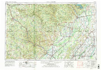
1957 Map of Poplar Bluff
USGS Topo · Published 1979About this map
The Ozark Plateau and the fertile lowlands of the Mississippi embayment meet along a sharp geological divide, dominated by the prominent elevation of Crowleys Ridge. This 1970s revision of a mid-century survey illustrates a complex hydrological landscape where the Current River, Black River, and St. Francis River flow toward the Arkansas border. Commercial hubs like Poplar Bluff and West Plains anchor the Missouri side, while the railroad corridor through Pocahontas and Walnut Ridge defines the regional transit network in Arkansas. The map captures the transition from the densely forested reaches of the Mark Twain National Forest to the managed wetlands of the Mingo National Wildlife Refuge. Traces of the region's agricultural and industrial heritage are visible in the many small river towns and the expansive reach of the St. Louis-San Francisco Railway lines.
Find a feature on this map
160 named features on this map. Tap any name to fly to it.
Don’t see what you’re looking for? This feature index may not catch every label — zoom into the map to look around manually.
Map Details
Editions of this 1957 Poplar Bluff Map
3 editions found

Other maps of this area

1890 · Batesville
USGS Topo · 1:125,000

1890 · Mountain Home
USGS Topo · 1:125,000

1891 · Mountain Home
USGS Topo · 1:125,000

1891 · Batesville
USGS Topo · 1:125,000

1892 · Mountain View
USGS Topo · 1:125,000

1894 · Mountain View
USGS Topo · 1:125,000

1894 · Mountain Home
USGS Topo · 1:125,000

1915 · Eminence
USGS Topo · 1:62,500

1917 · Eminence
USGS Topo · 1:62,500

1928 · Cardareva
USGS Topo · 1:62,500