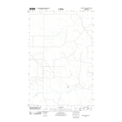
2011 Map of Poplar Coulee
USGS Topo · Published 2011About this map
Poplar Coulee defines the drainage patterns of this northern Montana landscape, where the seasonal waters of Cottonwood Creek wind through the terrain near the Wolf Point District. This 2011 United States Geological Survey record illustrates a primarily rural and agricultural network, emphasizing the section lines and local transit routes that organize the region. The map detail highlights the sparse infrastructure of the high plains, centering on key local thoroughfares like Winderal Rd and Kegel Rd, which provide access to the vast ranchlands and open coulees characteristic of Roosevelt County.
Find a feature on this map
4 named features on this map. Tap any name to fly to it.
Don’t see what you’re looking for? This feature index may not catch every label — zoom into the map to look around manually.
Map Details
Editions of this 2011 Poplar Coulee Map
This is the sole edition of this map. No revisions or reprints were ever made.
Other maps of this area

1910 · Todd Lakes
USGS Topo · 1:62,500

1915 · Tule Valley
USGS Topo · 1:62,500

1915 · Todd Lakes
USGS Topo · 1:62,500

1954 · Wolf Point
USGS Topo · 1:250,000

1958 · Wolf Point
USGS Topo · 1:250,000

1973 · West Fork NE
USGS Topo · 1:24,000

1973 · Haugens Hill
USGS Topo · 1:24,000

1973 · Peerless 4 SW
USGS Topo · 1:24,000

1973 · Poplar Coulee
USGS Topo · 1:24,000
1973 · West Fork
USGS Topo · 1:24,000