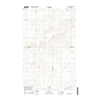
2014 Map of Poplar Coulee
USGS Topo · Published 2014About this map
Poplar Coulee and the drainage of Cottonwood Cr define this rural landscape at the intersection of Daniels, Valley, and Roosevelt counties. This 2014 survey documents a portion of the northern plains where the land is primarily partitioned by a grid of section lines and gravel paths like Wilcoxon Rd and Kegel Rd. Water is the primary driver of names in this environment, with features such as Shipstead Coulee and the specifically identified 33N45E26DBAD01 Spring providing essential reference points. The map illustrates the sparse settlement patterns and topography characteristic of the Wolf Point District, showing how modern infrastructure follows the ancient paths carved by seasonal watercourses and prairie springs.
Find a feature on this map
14 named features on this map. Tap any name to fly to it.
Don’t see what you’re looking for? This feature index may not catch every label — zoom into the map to look around manually.
Map Details
Editions of this 2014 Poplar Coulee Map
This is the sole edition of this map. No revisions or reprints were ever made.
Other maps of this area

1910 · Todd Lakes
USGS Topo · 1:62,500

1915 · Tule Valley
USGS Topo · 1:62,500

1915 · Todd Lakes
USGS Topo · 1:62,500

1954 · Wolf Point
USGS Topo · 1:250,000

1958 · Wolf Point
USGS Topo · 1:250,000

1973 · West Fork NE
USGS Topo · 1:24,000

1973 · Haugens Hill
USGS Topo · 1:24,000

1973 · Peerless 4 SW
USGS Topo · 1:24,000

1973 · Poplar Coulee
USGS Topo · 1:24,000
1973 · West Fork
USGS Topo · 1:24,000