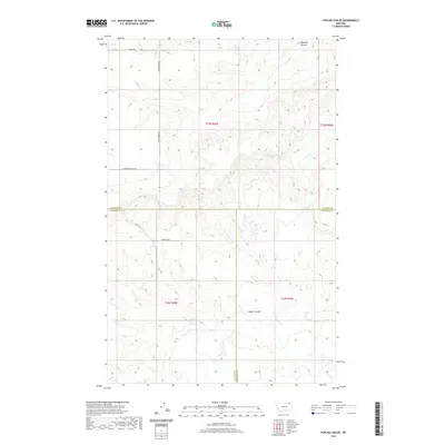
2020 Map of Poplar Coulee
USGS Topo · Published 2020About this map
Poplar Coulee and Cottonwood Cr drainage systems define this landscape at the intersection of Daniels, Valley, and Roosevelt counties. This northeastern Montana terrain is marked by a network of rural routes that follow both section lines and natural contours, including W Willcoxon Rd and Winderal Rd. The land is characterized by its drainage patterns, with Shipstead Coulee in the north and a specific water source identified as 33N45E26DBAD01 Spring near the center. The map illustrates the structured Public Land Survey System layout of Townships 32 and 33 North, providing a clear view of the ranching and agricultural framework of the region. Local access is maintained through named tracks such as Kegel Rd and E Pleasant View Rd, which navigate the elevation changes between the coulees and the higher plains.
Find a feature on this map
16 named features on this map. Tap any name to fly to it.
Don’t see what you’re looking for? This feature index may not catch every label — zoom into the map to look around manually.
Map Details
Editions of this 2020 Poplar Coulee Map
This is the sole edition of this map. No revisions or reprints were ever made.
Other maps of this area

1910 · Todd Lakes
USGS Topo · 1:62,500

1915 · Tule Valley
USGS Topo · 1:62,500

1915 · Todd Lakes
USGS Topo · 1:62,500

1954 · Wolf Point
USGS Topo · 1:250,000

1958 · Wolf Point
USGS Topo · 1:250,000

1973 · West Fork NE
USGS Topo · 1:24,000

1973 · Haugens Hill
USGS Topo · 1:24,000

1973 · Peerless 4 SW
USGS Topo · 1:24,000

1973 · Poplar Coulee
USGS Topo · 1:24,000
1973 · West Fork
USGS Topo · 1:24,000