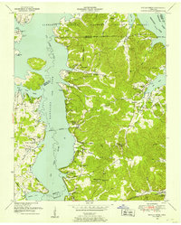
1949 Map of Poplar Creek
USGS Topo · Published 1953About this map
Kentucky Lake and the Big Sandy River dominate this 1949 survey of the Benton County shoreline, where the Tennessee National Migratory Wildlife Refuge spans the convoluted western banks. The map reveals a transition from river-bottom landings like Iron Bridge Landing and Sulphur Well Landing to the upland ridges and hollows that define the interior. The local landscape is deeply etched with small-scale agriculture and community life, evidenced by a dense network of family-named cemeteries and rural houses of worship, including Mt Zion Church and Oak Hill Ch. The Louisville and Nashville railroad cuts across the southeast corner near Faxon, providing a critical transportation link for the timber and farming communities tucked away in McSwain Hollow and Homer Hollow.
Find a feature on this map
49 named features on this map. Tap any name to fly to it.
Don’t see what you’re looking for? This feature index may not catch every label — zoom into the map to look around manually.
Map Details
Editions of this 1949 Poplar Creek Map
3 editions found
Other maps of this area

1936 · Poplar Creek
USGS Topo · 1:24,000

1936 · Buchanan
USGS Topo · 1:24,000

1936 · McKinnon
USGS Topo · 1:24,000

1936 · Big Sandy
USGS Topo · 1:24,000

1936 · Centerville Landing
USGS Topo · 1:24,000

1936 · Harmon Creek
USGS Topo · 1:24,000

1936 · Standing Rock
USGS Topo · 1:24,000

1936 · Manleyville
USGS Topo · 1:24,000

1936 · Springville
USGS Topo · 1:24,000

1938 · Springville
USGS Topo · 1:24,000