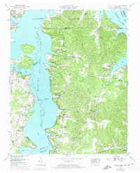
1949 Map of Poplar Creek
USGS Topo · Published 1974About this map
Kentucky Lake and the Tennessee River dominate this landscape on the border of Henry and Benton counties, shown here as it transitioned through mid-century revisions. The 1949 data, updated with 1973 photogrammetric revisions, reveals a territory defined by its relationship to the water and the Tennessee National Migratory Wildlife Refuge. For genealogists, the map is a dense record of rural community life, preserving the locations of numerous family cemeteries such as Culpepper Cem, Evans Cem, and Stockdale Cem. Religious life is equally well-documented through centers like Mt Vincent Church and Hill Chapel. The transportation network relies on historical river access points like Lick Creek Landing and New Hope Landing, alongside the tracks of the Louisville and Nashville railroad crossing the southern terrain near Faxon. Small settlements like Valentine and Matheny are shown tucked away in hollows like McSwain Hollow, offering a detailed look at the post-war Tennessee backcountry.
Find a feature on this map
53 named features on this map. Tap any name to fly to it.
Don’t see what you’re looking for? This feature index may not catch every label — zoom into the map to look around manually.
Map Details
Editions of this 1949 Poplar Creek Map
3 editions found
Other maps of this area

1936 · Poplar Creek
USGS Topo · 1:24,000

1936 · Buchanan
USGS Topo · 1:24,000

1936 · McKinnon
USGS Topo · 1:24,000

1936 · Big Sandy
USGS Topo · 1:24,000

1936 · Centerville Landing
USGS Topo · 1:24,000

1936 · Harmon Creek
USGS Topo · 1:24,000

1936 · Standing Rock
USGS Topo · 1:24,000

1936 · Manleyville
USGS Topo · 1:24,000

1936 · Springville
USGS Topo · 1:24,000

1938 · Springville
USGS Topo · 1:24,000