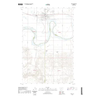
2020 Map of Poplar
USGS Topo · Published 2020About this map
The Poplar townsite serves as a focal point on the Fort Peck Indian Reservation where the Poplar River joins the Missouri River. This modern survey details the local infrastructure, including the Fort Peck Community College campus and the Poplar Cem situated near the town center. The landscape is defined by the significant confluence of three water systems: the Missouri, the Poplar, and the Redwater River, which winds through the southern portion of the quadrangle. North of the main settlement, Boys Bend marks a sharp meander in the Poplar River, while the surrounding plains are cut by seasonal drainages such as Hubbard Coulee and Glendive Coulee. Transportation across the river systems is anchored by the West Poplar River Bridge, connecting the town to the rural reaches of Roosevelt County and the neighboring boundaries of Richland and McCone counties.
Find a feature on this map
42 named features on this map. Tap any name to fly to it.
Don’t see what you’re looking for? This feature index may not catch every label — zoom into the map to look around manually.
Map Details
Editions of this 2020 Poplar Map
This is the sole edition of this map. No revisions or reprints were ever made.
Other maps of this area

1912 · Chelsea
USGS Topo · 1:62,500

1912 · Poplar
USGS Topo · 1:62,500

1954 · Glendive
USGS Topo · 1:250,000

1954 · Wolf Point
USGS Topo · 1:250,000

1957 · Glendive
USGS Topo · 1:250,000

1958 · Wolf Point
USGS Topo · 1:250,000

1958 · Glendive
USGS Topo · 1:250,000

1972 · Poplar
USGS Topo · 1:24,000

1972 · Chelsea
USGS Topo · 1:24,000

1972 · Poplar NE
USGS Topo · 1:24,000
Featured Places
- Poplar District, MT
- Poplar, Poplar District
- Brockton District, MT
- Roosevelt County, MT
- McCone County, MT