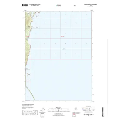
2017 Map of Port Alexander A-2 NW
USGS Topo · Published 2017About this map
Port Alexander occupies a narrow strip of coastline on the southern tip of Baranof Island, positioned where the open waters of the Gulf of Alaska meet the intricate shorelines of the Alexander Archipelago. This remote maritime outpost is largely enveloped by the Tongass National Forest, illustrating the isolated character of Southeast Alaskan settlements that rely entirely on the sea for connectivity. The coastline is defined by sharp geographic markers such as Cape Ommaney and the nearby Wooden Island, which have long served as critical navigational landfalls for mariners entering these waters. To the east, Breakfast Rock sits amidst the tides, while the map also tracks the administrative boundary of the Prince of Wales-Hyder Census Area, marking a point of transition between regional jurisdictions in this sparsely populated wilderness.
Find a feature on this map
12 named features on this map. Tap any name to fly to it.
Don’t see what you’re looking for? This feature index may not catch every label — zoom into the map to look around manually.
Map Details
Editions of this 2017 Port Alexander A-2 NW Map
This is the sole edition of this map. No revisions or reprints were ever made.
Other maps of this area

1948 · Port Alexander A-2
USGS Topo · 1:63,360
1948 · Port Alexander A-3
USGS Topo · 1:63,360

1948 · Port Alexander B-2
USGS Topo · 1:63,360

1951 · Port Alexander B-3 and B-4
USGS Topo · 1:63,360

1951 · Port Alexander
USGS Topo · 1:250,000

1951 · Port Alexander B-2
USGS Topo · 1:63,360
1951 · Port Alexander A-3
USGS Topo · 1:63,360
1951 · Port Alexander A-2
USGS Topo · 1:63,360

1952 · Port Alexander
USGS Topo · 1:250,000

1964 · Port Alexander
USGS Topo · 1:250,000