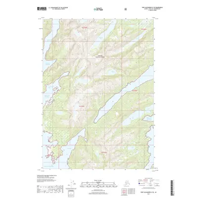
2017 Map of Port Alexander B-3 SE
USGS Topo · Published 2017About this map
Tongass National Forest dominates this coastal Alaskan landscape, where the sea meets a complex network of freshwater catchments and deep-water inlets. The topography is defined by significant drainage systems, including Sashin Cr which flows from the elevated Sashin Lake toward the coast. The southeastern shoreline is punctuated by Port Lucy, a prominent narrow inlet, while the southern boundary is marked by the wide mouth of Puffin Bay. These coastal features, along with Big Branch Bay and Little Branch Bay to the west, illustrate the maritime-influenced geography typical of this region of the Alexander Archipelago. Numerous isolated freshwater bodies like Borodino Lake, Betty Lake, and Leona Lake are scattered throughout the interior, providing a detailed look at the island's hydrology before the turn of the decade.
Find a feature on this map
20 named features on this map. Tap any name to fly to it.
Don’t see what you’re looking for? This feature index may not catch every label — zoom into the map to look around manually.
Map Details
Editions of this 2017 Port Alexander B-3 SE Map
This is the sole edition of this map. No revisions or reprints were ever made.
Other maps of this area

1948 · Port Alexander A-2
USGS Topo · 1:63,360
1948 · Port Alexander A-3
USGS Topo · 1:63,360

1948 · Port Alexander B-2
USGS Topo · 1:63,360

1951 · Port Alexander B-3 and B-4
USGS Topo · 1:63,360

1951 · Port Alexander
USGS Topo · 1:250,000

1951 · Port Alexander B-2
USGS Topo · 1:63,360
1951 · Port Alexander A-3
USGS Topo · 1:63,360
1951 · Port Alexander A-2
USGS Topo · 1:63,360

1952 · Port Alexander
USGS Topo · 1:250,000

1964 · Port Alexander
USGS Topo · 1:250,000