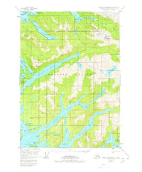
1951 Map of Port Alexander D-4
USGS Topo · Published 1978About this map
Baranof Island is defined by its deep fjords and glacial lakes in this mid-century survey of the terrain south of Sitka. The landscape is dominated by the massive Redoubt Lake and the intricate branching of Crawfish Inlet and West Crawfish Inlet. Evidence of early industrial and transit activity is visible via the Power Site Trail near Green Lake and a solitary Mine located on the slopes of Eureka Mountain near Silver Bay. The hydrographic data, compiled from Coast and Geodetic Survey charts, captures the precise coastline of Deep Inlet and the Rakof Islands. Scattered cabins along the shoreline and interior lakes like Salmon Lake suggest a seasonal or subsistence presence in this remote maritime environment.
Find a feature on this map
45 named features on this map. Tap any name to fly to it.
Don’t see what you’re looking for? This feature index may not catch every label — zoom into the map to look around manually.
Map Details
Editions of this 1951 Port Alexander D-4 Map
4 editions found
Other maps of this area

1948 · Sitka A-5
USGS Topo · 1:63,360

1948 · Sitka A-3
USGS Topo · 1:63,360

1951 · Port Alexander D-5
USGS Topo · 1:63,360

1951 · Sitka
USGS Topo · 1:250,000

1951 · Port Alexander C-4
USGS Topo · 1:63,360

1951 · Port Alexander D-4
USGS Topo · 1:63,360

1951 · Port Alexander C-3
USGS Topo · 1:63,360

1951 · Port Alexander D-3
USGS Topo · 1:63,360

1951 · Port Alexander
USGS Topo · 1:250,000

1951 · Sitka A-4
USGS Topo · 1:63,360