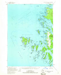
1951 Map of Port Alexander D-5
USGS Topo · Published 1965About this map
Biorka Island and the complex archipelago of Sitka Sound define this coastal landscape, which was meticulously field-annotated in the early 1950s. The map details the transition from the open Pacific Ocean into sheltered waters like Redoubt Bay and Kanga Bay. Evidence of localized settlement is visible at Goddard near the Hot Springs, as well as various clusters of cabins scattered along the rocky shorelines of the Taigud Islands and Legma Island.
Find a feature on this map
109 named features on this map. Tap any name to fly to it.
Don’t see what you’re looking for? This feature index may not catch every label — zoom into the map to look around manually.
Map Details
Editions of this 1951 Port Alexander D-5 Map
Other maps of this area

1948 · Sitka A-5
USGS Topo · 1:63,360

1951 · Sitka A-6
USGS Topo · 1:63,360

1951 · Port Alexander D-5
USGS Topo · 1:63,360

1951 · Sitka
USGS Topo · 1:250,000

1951 · Port Alexander C-4
USGS Topo · 1:63,360

1951 · Port Alexander D-4
USGS Topo · 1:63,360

1951 · Port Alexander
USGS Topo · 1:250,000

1951 · Sitka A-4
USGS Topo · 1:63,360

1951 · Sitka A-5
USGS Topo · 1:63,360

1952 · Port Alexander
USGS Topo · 1:250,000