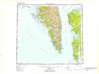
1951 Map of Port Alexander
USGS Topo · Published 1959About this map
Baranof Island and Kuiu Island define the intricate coastlines of this 1951 survey, where the maritime economy of Southeast Alaska is recorded through numerous small outposts and cannery sites. Along the protected eastern shore of Baranof, coastal activity is concentrated at Port Alexander, Port Armstrong, and the research-focused Port Walter. The map captures the remote settlement of Goddard (Hot Springs P O) on the western coast near Sitka Sound, highlighting the importance of localized postal and supply hubs in this era before modern infrastructure. These maritime landings, often situated at the mouths of deep inlets like Whale Bay and Tebenkof Bay, served as the primary connection points for regional industry. Navigational landmarks like Cape Ommaney and the Cape Decision lighthouse guide the way through Chatham Strait, while the St Lazaria National Wildlife Refuge marks early conservation efforts on the seaward islands.
Find a feature on this map
61 named features on this map. Tap any name to fly to it.
Don’t see what you’re looking for? This feature index may not catch every label — zoom into the map to look around manually.
Map Details
Editions of this 1951 Port Alexander Map
5 editions found

Other maps of this area

1948 · Sitka A-5
USGS Topo · 1:63,360

1948 · Sitka A-3
USGS Topo · 1:63,360

1948 · Sitka A-2
USGS Topo · 1:63,360

1948 · Port Alexander C-1
USGS Topo · 1:63,360

1948 · Petersburg A-6
USGS Topo · 1:63,360

1948 · Port Alexander A-1
USGS Topo · 1:63,360

1948 · Petersburg B-6
USGS Topo · 1:63,360

1948 · Sumdum A-6
USGS Topo · 1:63,360

1948 · Port Alexander B-1
USGS Topo · 1:63,360

1948 · Petersburg D-6
USGS Topo · 1:63,360