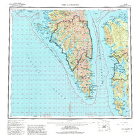
1951 Map of Port Alexander
USGS Topo · Published 1995About this map
Baranof Island and Kuiu Island anchor this mid-century survey of the Alexander Archipelago, showing a landscape defined by deep fjords and isolated maritime outposts. The settlement of Port Alexander sits near the southern tip of Baranof, serving as a focal point for a region where transport was almost exclusively waterborne. To the north, the Lucky Chance Mine indicates the era's industrial activity tucked into the mountainous interior near Redoubt Lake.
Find a feature on this map
82 named features on this map. Tap any name to fly to it.
Don’t see what you’re looking for? This feature index may not catch every label — zoom into the map to look around manually.
Map Details
Editions of this 1951 Port Alexander Map
5 editions found

Other maps of this area

1948 · Sitka A-5
USGS Topo · 1:63,360

1948 · Sitka A-3
USGS Topo · 1:63,360

1948 · Sitka A-2
USGS Topo · 1:63,360

1948 · Port Alexander C-1
USGS Topo · 1:63,360

1948 · Petersburg A-6
USGS Topo · 1:63,360

1948 · Port Alexander A-1
USGS Topo · 1:63,360

1948 · Petersburg B-6
USGS Topo · 1:63,360

1948 · Sumdum A-6
USGS Topo · 1:63,360

1948 · Port Alexander B-1
USGS Topo · 1:63,360

1948 · Petersburg D-6
USGS Topo · 1:63,360