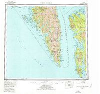
1951 Map of Port Alexander
USGS Topo · Published 1978About this map
Baranof Island and Kuiu Island dominate this mid-century survey of the Alexander Archipelago, showing a landscape defined by deep fjords and isolated maritime outposts. At the southern tip of Baranof, Port Alexander and the nearby Port Armstrong and Port Herbert serve as primary anchors for the region's fishing and maritime activities. The inland terrain is marked by high peaks like Mt Elizabeth and Rudakof Mountain, while industrial activity is noted at the Lucky Chance Min.
Find a feature on this map
65 named features on this map. Tap any name to fly to it.
Don’t see what you’re looking for? This feature index may not catch every label — zoom into the map to look around manually.
Map Details
Editions of this 1951 Port Alexander Map
5 editions found

Other maps of this area

1948 · Sitka A-5
USGS Topo · 1:63,360

1948 · Sitka A-3
USGS Topo · 1:63,360

1948 · Sitka A-2
USGS Topo · 1:63,360

1948 · Port Alexander C-1
USGS Topo · 1:63,360

1948 · Petersburg A-6
USGS Topo · 1:63,360

1948 · Port Alexander A-1
USGS Topo · 1:63,360

1948 · Petersburg B-6
USGS Topo · 1:63,360

1948 · Sumdum A-6
USGS Topo · 1:63,360

1948 · Port Alexander B-1
USGS Topo · 1:63,360

1948 · Petersburg D-6
USGS Topo · 1:63,360