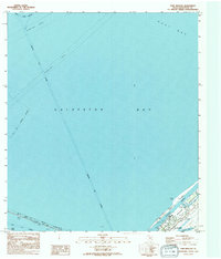
1994 Map of Port Bolivar
USGS Topo · Published 1994About this map
Port Bolivar sits at the tip of the Bolivar Peninsula, serving as a critical junction where maritime commerce meets coastal life. This late-twentieth-century maritime study shows a landscape defined by engineered waterways, including the deep-draft Houston Ship Channel and the Intracoastal Waterway, which carve through the waters of Galveston Bay. A legacy of transit is visible in the Old Railroad Gr, reflecting historical overland connections that predated modern infrastructure. Along the shoreline, protective features like the Seawall and various Levees highlight the ongoing effort to manage the intersection of the Texas coast and the Gulf's influence. Small-scale local details, such as the Horseshoe Lake and the Po, provide a view into the daily layout of this coastal settlement before more recent development.
Find a feature on this map
19 named features on this map. Tap any name to fly to it.
Don’t see what you’re looking for? This feature index may not catch every label — zoom into the map to look around manually.
Map Details
Editions of this 1994 Port Bolivar Map
This is the sole edition of this map. No revisions or reprints were ever made.
Other maps of this area

1929 · Virginia Point
USGS Topo · 1:24,000

1929 · Texas City
USGS Topo · 1:24,000

1930 · Galveston
USGS Topo · 1:24,000

1931 · Flake
USGS Topo · 1:24,000

1932 · Clifton By The Sea
USGS Topo · 1:31,680

1932 · Texas City
USGS Topo · 1:31,680

1932 · Bolivar Point
USGS Topo · 1:24,000

1932 · Virginia Point
USGS Topo · 1:31,680

1933 · The Jetties
USGS Topo · 1:31,680

1933 · Whites Lake
USGS Topo · 1:31,680