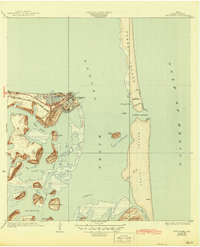
1934 Map of Port Isabel
USGS Topo · Published 1945About this map
Port Isabel stands as the primary hub along the South Texas coast in this mid-1940s reprint of a 1929 survey. The town's grid and Yacht Club overlook the vast Laguna Madre, where the Port Isabel and Rio Grande Valley railroad terminates at the shoreline. This map illustrates the vital maritime infrastructure of the era, including the Brazos Santiago LH lighthouse and the Brazos Coast Guard Sta, which protected the pass between Padre Island and Brazos Island.
Find a feature on this map
40 named features on this map. Tap any name to fly to it.
Don’t see what you’re looking for? This feature index may not catch every label — zoom into the map to look around manually.
Map Details
Editions of this 1934 Port Isabel Map
2 editions found
Other maps of this area

1929 · La Coma
USGS Topo · 1:24,000

1929 · Palmito Hill
USGS Topo · 1:24,000

1929 · Point Isabel
USGS Topo · 1:24,000

1929 · Laguna Vista
USGS Topo · 1:24,000

1930 · Padre Island No. 1
USGS Topo · 1:24,000

1934 · Port Isabel
USGS Topo · 1:31,680

1934 · La Coma
USGS Topo · 1:31,680

1935 · Padre Island No 1
USGS Topo · 1:31,680

1936 · Palmito Hill
USGS Topo · 1:31,680

1936 · Laguna Vista
USGS Topo · 1:31,680