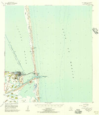
1955 Map of Port Isabel
USGS Topo · Published 1957About this map
Port Isabel serves as the gateway to the southern coast in the mid-1950s, a period marked by the early development of the barrier island tourist economy. The Queen Isabella Causeway provides the critical vehicular link from the mainland to the shifting dunes of Padre Island, where Andy Bowie Park and Isla Blanca Park begin to define the recreational landscape. This era shows a coastal infrastructure in transition, featuring the Missouri Pacific Railroad terminating near a shoreline Refinery and the US Coast Guard Station guarding the Brazos Santiago Pass. Inland, the terrain is characterized by a series of prominent clay dunes or lomas, such as Loma Ochoa and Loma de las Gachupines, which rise above the surrounding mudflats. These natural landmarks, along with the Intracoastal Waterway cutting through Laguna Madre, illustrate the intersection of maritime commerce and the unique Rio Grande delta topography.
Find a feature on this map
44 named features on this map. Tap any name to fly to it.
Don’t see what you’re looking for? This feature index may not catch every label — zoom into the map to look around manually.
Map Details
Editions of this 1955 Port Isabel Map
This is the sole edition of this map. No revisions or reprints were ever made.
Other maps of this area

1929 · La Coma
USGS Topo · 1:24,000

1929 · Palmito Hill
USGS Topo · 1:24,000

1929 · Point Isabel
USGS Topo · 1:24,000

1929 · Buena Vista
USGS Topo · 1:24,000

1929 · Laguna Vista
USGS Topo · 1:24,000

1930 · Padre Island No. 1
USGS Topo · 1:24,000

1930 · Padre Island No. 2
USGS Topo · 1:24,000

1934 · Port Isabel
USGS Topo · 1:31,680

1934 · La Coma
USGS Topo · 1:31,680

1935 · Padre Island No 1
USGS Topo · 1:31,680