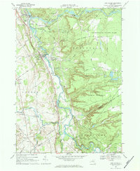
1966 Map of Port Leyden
USGS Topo · Published 1984About this map
The Black River and Moose River converge at Lyons Falls, anchoring a landscape of industrial hamlets and riverside settlements during the mid-1960s. This territory in the foothills of the Adirondack State Park shows a well-established network of small towns including Port Leyden and Kosterville, linked by the Penn Central railroad corridors. The presence of multiple historic religious and memorial sites, such as Gould Memorial Chapel and Fisher Mem Chapel, alongside legacy burial grounds like Wildwood Cem and Leyden Hill Cem, provides significant detail for genealogical research. To the south, the Sugar River winds past Talcottville, while the eastern portion of the map transitions into the protected State Forest Preserve, where rugged terrain is marked by features like Hells Kitchen and numerous mountain brooks.
Find a feature on this map
66 named features on this map. Tap any name to fly to it.
Don’t see what you’re looking for? This feature index may not catch every label — zoom into the map to look around manually.
Map Details
Editions of this 1966 Port Leyden Map
2 editions found
Other maps of this area

1897 · Remsen
USGS Topo · 1:62,500

1900 · Remsen
USGS Topo · 1:62,500

1904 · Boonville
USGS Topo · 1:62,500

1905 · Port Leyden
USGS Topo · 1:62,500

1907 · Port Leyden
USGS Topo · 1:62,500

1912 · Mc Keever
USGS Topo · 1:62,500

1940 · Port Leyden
USGS Topo · 1:62,500

1945 · Boonville
USGS Topo · 1:24,000

1945 · Forestport
USGS Topo · 1:24,000
1946 · West Leyden
USGS Topo · 1:31,680