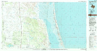
1985 Map of Port Mansfield
USGS Topo · Published 1992About this map
Laguna Madre dominates the eastern landscape of this South Texas coastal region, where the shallow waters separate the mainland from the Padre Island National Seashore. The inland terrain is characterized by a sparse network of small ranching and rail settlements, many established along the corridor of the Missouri Pacific Railroad. Places such as Norias, Armstrong, and Rudolph illustrate the historical importance of rail transit through the scrubland and dunes of the Kenedy and Willacy county lines. Further south, the map details the transition into more established irrigation and agricultural zones near San Perlita. The map also captures the maritime infrastructure of the era, from the Intracoastal Waterway to the harbor at Port Mansfield. Natural landmarks like the salt lake of La Sal Vieja and various named elevations like Ebony Hill provide clear reference points for the low-lying coastal plains.
Find a feature on this map
47 named features on this map. Tap any name to fly to it.
Don’t see what you’re looking for? This feature index may not catch every label — zoom into the map to look around manually.
Map Details
Editions of this 1985 Port Mansfield Map
2 editions found
Other maps of this area

1921 · Falfurrias
USGS Topo · 1:125,000

1921 · Tarida Ranch
USGS Topo · 1:62,500

1922 · La Sal Vieja
USGS Topo · 1:62,500

1923 · Armstrong
USGS Topo · 1:62,500

1923 · Lopena Island
USGS Topo · 1:62,500

1923 · Saltillo Ranch
USGS Topo · 1:62,500

1928 · Sarita
USGS Topo · 1:125,000

1939 · Linn
USGS Topo · 1:62,500

1949 · Mc Allen
USGS Topo · 1:250,000

1950 · Corpus Christi
USGS Topo · 1:250,000