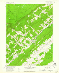
1959 Map of Port Matilda
USGS Topo · Published 1960About this map
Bald Eagle Mountain dominates this mid-century landscape, separating the industrial and transport corridor of the Bald Eagle Creek valley from the undulating terrain of Halfmoon Valley. The small borough of Port Matilda serves as a central hub where the Pennsylvania railroad and several highways converge. To the northeast, the historic industrial site at Martha Furnace stands near the creek, while the southeastern corner of the map transitions into the unique geological area known as The Barrens.
Find a feature on this map
50 named features on this map. Tap any name to fly to it.
Don’t see what you’re looking for? This feature index may not catch every label — zoom into the map to look around manually.
Map Details
Editions of this 1959 Port Matilda Map
4 editions found
Other maps of this area

1908 · Bellefonte
USGS Topo · 1:62,500

1909 · Bellefonte
USGS Topo · 1:62,500

1919 · Menno
USGS Topo · 1:62,500

1922 · Philipsburg
USGS Topo · 1:62,500

1923 · Tyrone
USGS Topo · 1:62,500

1929 · Tyrone
USGS Topo · 1:48,000

1933 · Tyrone
USGS Topo · 1:62,500

1935 · Allensville
USGS Topo · 1:62,500

1938 · Allensville
USGS Topo · 1:62,500

1939 · Philipsburg
USGS Topo · 1:62,500