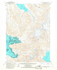
1963 Map of Port Moller D-1
USGS Topo · Published 1987About this map
Bear Lake and the glacial drainages of the Milky River dominate this coastal landscape on the Alaska Peninsula during the early 1960s. The map illustrates a complex network of waterways, where the King Salmon River and various unnamed streams flow through low-lying marshlands toward the expansive Port Moller Left Head and Port Moller Right Head. These tidal flats, marked by mud and intricate shoals, provide a snapshot of the region's hydrography as it was recorded during aerial surveys in the late 1950s.
Find a feature on this map
12 named features on this map. Tap any name to fly to it.
Don’t see what you’re looking for? This feature index may not catch every label — zoom into the map to look around manually.
Map Details
Editions of this 1963 Port Moller D-1 Map
2 editions found
Other maps of this area

1951 · Stepovak Bay
USGS Topo · 1:250,000

1953 · Port Moller
USGS Topo · 1:250,000

1963 · Port Moller C-2
USGS Topo · 1:63,360

1963 · Chignik A-6
USGS Topo · 1:63,360

1963 · Port Moller C-1
USGS Topo · 1:63,360

1963 · Chignik A-7
USGS Topo · 1:63,360

1963 · Stepovak Bay D-6
USGS Topo · 1:63,360

1963 · Port Moller D-2
USGS Topo · 1:63,360

1963 · Chignik
USGS Topo · 1:250,000
1963 · Chignik A-8
USGS Topo · 1:63,360