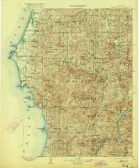
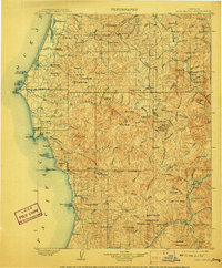
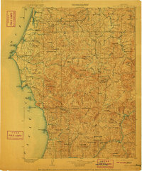
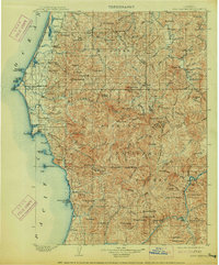
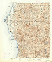
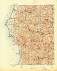
1903 Map of Port Orford
USGS Topo · Published 1922About this map
Port Orford serves as the coastal anchor for this maritime and mountain landscape, surveyed just before the turn of the century when the rugged shoreline of Curry County was sparsely settled. The map reveals a string of isolated coastal outposts like Frankport and Ophir connected by trails along the Pacific Ocean, while the interior is dominated by the newly established Siskiyou National Forest. Dramatic coastal landmarks including Cape Blanco and Humbug Mt. mark the transition from the sea to the steep, densely forested ridges of the Klamath Mountains. Inland, the Rogue River carves through the terrain at Big Bend, providing a vital corridor toward the small settlement of Agness. The distribution of coastal lakes like Floras Lake and Garrison Lagoon indicates a landscape shaped by shifting sands and powerful Pacific tides, where travel was dictated by the river valleys and the rocky headlands of The Heads and Blacklock Pt.
Find a feature on this map
115 named features on this map. Tap any name to fly to it.
Don’t see what you’re looking for? This feature index may not catch every label — zoom into the map to look around manually.
Map Details
Editions of this 1903 Port Orford Map
7 editions found
Other maps of this area

1896 · Coos Bay
USGS Topo · 1:125,000

1898 · Coos Bay
USGS Topo · 1:125,000

1899 · Port Orford
USGS Topo · 1:125,000

1900 · Coos Bay
USGS Topo · 1:125,000

1903 · Port Orford
USGS Topo · 1:125,000

1917 · Kerby
USGS Topo · 1:125,000

1918 · Kerby
USGS Topo · 1:125,000

1928 · Sitkum
USGS Topo · 1:125,000

1942 · Coquille
USGS Topo · 1:62,500
1943 · Bandon
USGS Topo · 1:62,500