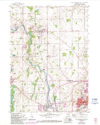
1959 Map of Port Washington West
USGS Topo · Published 1994About this map
The Milwaukee River carves a winding path through this Ozaukee County landscape, anchoring the mid-century development of Waubeka, Saukville, and Fredonia. The map reveals a transition from the dense urban grid of Port Washington in the southeast to the rural townships of Belgium and Saukville. Family history is preserved through numerous small burial sites like the Katherina Cem and Waubeka Union Cem, alongside several rural schoolhouses such as McKinley Sch and Smoky Hill Sch that served these farming communities before consolidation.
Find a feature on this map
40 named features on this map. Tap any name to fly to it.
Don’t see what you’re looking for? This feature index may not catch every label — zoom into the map to look around manually.
Map Details
Editions of this 1959 Port Washington West Map
3 editions found
Other maps of this area

1892 · Port Washington
USGS Topo · 1:62,500

1904 · West Bend
USGS Topo · 1:62,500

1904 · Port Washington
USGS Topo · 1:62,500

1954 · Sheboygan Falls
USGS Topo · 1:62,500

1954 · Milwaukee
USGS Topo · 1:250,000

1955 · Kewaskum
USGS Topo · 1:62,500

1957 · Madison
USGS Topo · 1:250,000

1958 · Milwaukee
USGS Topo · 1:250,000
1958 · Port Washington East
USGS Topo · 1:24,000

1959 · Port Washington West
USGS Topo · 1:24,000