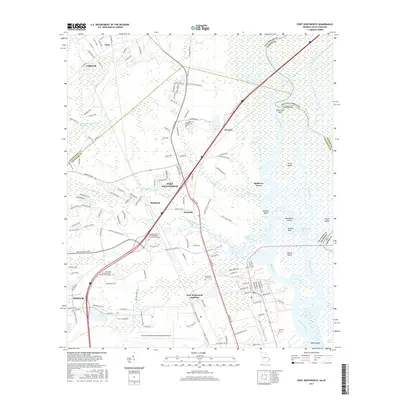
2017 Map of Port Wentworth
USGS Topo · Published 2017About this map
The Savannah River corridor and its intricate network of coastal waterways define this landscape on the border of Georgia and South Carolina. This modern survey details a region shaped by its proximity to the Atlantic, where the river splits into the Front River, Middle River, and Little Back River. The settlement pattern follows the high ground between these wetlands and the CSX rail line, connecting historic nodes like Monteith, Meinhard, and Port Wentworth. The map reflects the area's continued role as a transportation and industrial hub, indicated by the presence of the Savannah Hilton/Head International Airport and the Georgia Institute of Technology Savannah Campus. Away from the main transit corridors, the geography remains characterized by large islands and named cuts, such as Onslow Island and Drakies Cut, which have long dictated local navigation and land use.
Find a feature on this map
159 named features on this map. Tap any name to fly to it.
Don’t see what you’re looking for? This feature index may not catch every label — zoom into the map to look around manually.
Map Details
Editions of this 2017 Port Wentworth Map
This is the sole edition of this map. No revisions or reprints were ever made.
Other maps of this area

1919 · Egypt
USGS Topo · 1:62,500

1920 · Hardeeville
USGS Topo · 1:62,500

1920 · Meldrim
USGS Topo · 1:62,500

1939 · Egypt
USGS Topo · 1:62,500

1942 · Meldrim
USGS Topo · 1:62,500

1942 · Savannah
USGS Topo · 1:62,500

1943 · Hardeeville
USGS Topo · 1:62,500

1943 · Egypt
USGS Topo · 1:62,500

1947 · Savannah
USGS Topo · 1:250,000

1948 · Savannah
USGS Topo · 1:250,000