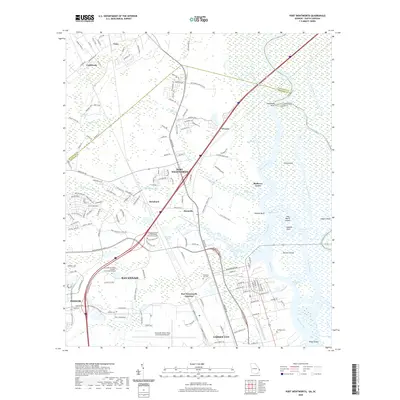
2020 Map of Port Wentworth
USGS Topo · Published 2020About this map
Port Wentworth and its surrounding industrial and residential corridors are defined by the intricate waterways of the Savannah River delta. The landscape is a complex network of marshes and islands, including Argyle Island and Onslow Island, separated by channels like Drakies Cut and Rhodes Cut. The map documents the northern expansion of the Savannah metropolitan area, where established communities like Meinhard and Monteith sit alongside modern logistical hubs. Transportation infrastructure is prominent, with the Savannah/Hilton Head International Airport and major thoroughfares like the Jimmy DeLoach Pkwy facilitating the region's commerce. Educational institutions such as the Georgia Institute of Technology - Savannah Campus indicate the area's development into a center for technology and technical training. Local history is anchored by sites like Cherokee Hill Cem and the former estate lands at Mulberry Grove.
Find a feature on this map
48 named features on this map. Tap any name to fly to it.
Don’t see what you’re looking for? This feature index may not catch every label — zoom into the map to look around manually.
Map Details
Editions of this 2020 Port Wentworth Map
This is the sole edition of this map. No revisions or reprints were ever made.
Other maps of this area

1919 · Egypt
USGS Topo · 1:62,500

1920 · Hardeeville
USGS Topo · 1:62,500

1920 · Meldrim
USGS Topo · 1:62,500

1939 · Egypt
USGS Topo · 1:62,500

1942 · Meldrim
USGS Topo · 1:62,500

1942 · Savannah
USGS Topo · 1:62,500

1943 · Hardeeville
USGS Topo · 1:62,500

1943 · Egypt
USGS Topo · 1:62,500

1947 · Savannah
USGS Topo · 1:250,000

1948 · Savannah
USGS Topo · 1:250,000