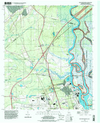
1993 Map of Port Wentworth
USGS Topo · Published 1998About this map
The Savannah River corridor and its intricate network of coastal waterways dominate this landscape during the mid-1990s. The map illustrates a complex hydraulic environment where the Front River, Middle River, and Back River diverge around substantial marshy landmasses like Argyle Island and Onslow Island. Industrial activity and civic infrastructure cluster around Port Wentworth and Garden City, including the Savannah Filtration Plant and a prominent Powerplant near the riverbanks.
Find a feature on this map
61 named features on this map. Tap any name to fly to it.
Don’t see what you’re looking for? This feature index may not catch every label — zoom into the map to look around manually.
Map Details
Editions of this 1993 Port Wentworth Map
This is the sole edition of this map. No revisions or reprints were ever made.
Other maps of this area

1919 · Egypt
USGS Topo · 1:62,500

1920 · Hardeeville
USGS Topo · 1:62,500

1920 · Meldrim
USGS Topo · 1:62,500

1939 · Egypt
USGS Topo · 1:62,500

1942 · Meldrim
USGS Topo · 1:62,500

1942 · Savannah
USGS Topo · 1:62,500

1943 · Hardeeville
USGS Topo · 1:62,500

1943 · Egypt
USGS Topo · 1:62,500

1947 · Savannah
USGS Topo · 1:250,000

1948 · Savannah
USGS Topo · 1:250,000