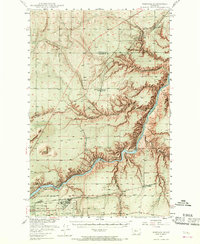
1948 Map of Portage
USGS Topo · Published 1968About this map
The Missouri River carves a deep, winding canyon through this portion of Montana, creating a dramatic break in the high plains just northeast of the city of Great Falls. This late-1940s landscape is defined by the heavy infrastructure of the river and the rail lines that parallel it, including the Rainbow Dam and the nearby State Fish Hatchery. The presence of the Great Falls Army Air Force Base at the southern edge of the sheet reflects the era's military footprint, while the State Deaf & Dumb School serves as a notable local landmark. Smaller agricultural and transport hubs like Portage, Salem, and Sheffels dot the territory, often situated near the Great Northern or Chicago Milwaukee St Paul and Pacific tracks. These small settlements and their associated schools, like Roosevelt Sch and Salem Sch, provide a clear record of rural social centers before the consolidation of later decades.
Find a feature on this map
31 named features on this map. Tap any name to fly to it.
Don’t see what you’re looking for? This feature index may not catch every label — zoom into the map to look around manually.
Map Details
Editions of this 1948 Portage Map
4 editions found
Other maps of this area

1886 · Great Falls
USGS Topo · 1:250,000

1890 · Fort Benton
USGS Topo · 1:250,000

1892 · Fort Benton
USGS Topo · 1:250,000

1897 · Fort Benton
USGS Topo · 1:250,000

1948 · Portage
USGS Topo · 1:62,500

1949 · Portage
USGS Topo · 1:62,500

1949 · Timber Coulee
USGS Topo · 1:62,500

1949 · Great Falls
USGS Topo · 1:62,500

1950 · Timber Coulee
USGS Topo · 1:62,500

1950 · Dent Bridge
USGS Topo · 1:62,500