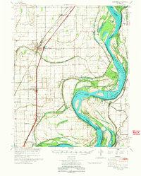
1973 Map of Portageville
USGS Topo · Published 1973About this map
Portageville and the surrounding alluvial plains of the Missouri Bootheel are defined here by a massive system of drainage canals, such as Main Ditch 18 and Ditch 52, which reclaimed the lowlands for agriculture. The Mississippi River dominates the eastern edge, carving deep loops like Little Cypress Bend and Merriwether Bend, while complex chutes like Pecan Chute and Tiptonville Chute illustrate the river's shifting nature near the Tennessee border.
Find a feature on this map
95 named features on this map. Tap any name to fly to it.
Don’t see what you’re looking for? This feature index may not catch every label — zoom into the map to look around manually.
Map Details
Editions of this 1973 Portageville Map
This is the sole edition of this map. No revisions or reprints were ever made.
Other maps of this area

1925 · Reelfoot Lake
USGS Topo · 1:62,500

1939 · Reelfoot Lake
USGS Topo · 1:62,500

1939 · Portageville
USGS Topo · 1:62,500

1939 · New Madrid
USGS Topo · 1:62,500

1939 · Bayouville
USGS Topo · 1:62,500

1939 · Dyersburg
USGS Topo · 1:62,500

1939 · Caruthersville
USGS Topo · 1:62,500

1940 · Malden
USGS Topo · 1:62,500

1940 · Pascola
USGS Topo · 1:62,500

1940 · Hayti
USGS Topo · 1:62,500