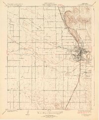
1929 Map of Porterville
USGS Topo · Published 1929About this map
Agricultural development in the San Joaquin Valley is defined here by an intricate web of irrigation works branching off the Tule River. The landscape is etched with named waterways like Porter Slough and Dead Horse Slough, alongside a systematic grid of ditches including the Hunsaker Ditch, Stockton Ditch, and Fine Ditch. These water systems supported a growing network of small rural school districts, with sites like Welcome Sch, Alta Robles Sch, and Olive Sch serving scattered farmsteads.
Find a feature on this map
36 named features on this map. Tap any name to fly to it.
Don’t see what you’re looking for? This feature index may not catch every label — zoom into the map to look around manually.
Map Details
Editions of this 1929 Porterville Map
3 editions found
Other maps of this area

1904 · Kaweah
USGS Topo · 1:125,000

1909 · Kaweah
USGS Topo · 1:125,000

1927 · Cairns Corner
USGS Topo · 1:31,680

1928 · Woodville
USGS Topo · 1:31,680

1928 · Lindsay
USGS Topo · 1:31,680

1929 · Sausalito School
USGS Topo · 1:31,680

1929 · Porterville
USGS Topo · 1:31,680

1929 · Ducor
USGS Topo · 1:31,680

1936 · White River
USGS Topo · 1:62,500

1936 · Tobias Peak
USGS Topo · 1:125,000