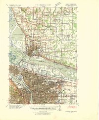
1940 Map of Portland
USGS Topo · Published 1940About this map
The Columbia River serves as the primary artery of this 1940 survey, separating Vancouver from Portland at a time of significant aviation and infrastructure growth. This map captures the region's diverse landscape, from the industrial docks of the Willamette River to the agricultural reaches of Fourth Plains. The importance of military and civil aviation is evident, with Vancouver Barracks anchored near Pearson Field while the Portland Columbia Airport and Port of Portland Airport on Swan Island show the era's expanding flight network.
Find a feature on this map
71 named features on this map. Tap any name to fly to it.
Don’t see what you’re looking for? This feature index may not catch every label — zoom into the map to look around manually.
Map Details
Editions of this 1940 Portland Map
4 editions found

Other maps of this area

1897 · Portland
USGS Topo · 1:62,500

1905 · Portland
USGS Topo · 1:62,500

1911 · Boring
USGS Topo · 1:48,000

1914 · Boring
USGS Topo · 1:62,500

1914 · Oregon City
USGS Topo · 1:62,500

1915 · Hillsboro
USGS Topo · 1:62,500

1916 · Tualatin
USGS Topo · 1:62,500

1916 · Estacada
USGS Topo · 1:125,000

1918 · Hillsboro
USGS Topo · 1:62,500

1918 · Troutdale
USGS Topo · 1:62,500