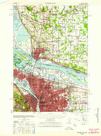
1940 Map of Portland
USGS Topo · Published 1958About this map
Portland and Vancouver dominate this 1940 topographic landscape, linked across the Columbia River by the Interstate Bridge. The era's burgeoning aviation industry is strikingly present with four distinct airfields: Pearson Field, Vancouver Airport, Portland Columbia Airport, and the Swan Island Port of Portland Airport. This period marks a transition in regional transit, where the river economy of Mundays Ferry and Russell Landing exists alongside heavy rail infrastructure like the Spokane Portland and Seattle Ry. Inland, the map documents numerous rural educational sites such as Felida School, Walnut School, and East Mill Plain School, providing a detailed record of local communities before post-war suburban expansion altered the edges of Fourth Plains.
Find a feature on this map
68 named features on this map. Tap any name to fly to it.
Don’t see what you’re looking for? This feature index may not catch every label — zoom into the map to look around manually.
Map Details
Editions of this 1940 Portland Map
4 editions found

Other maps of this area

1897 · Portland
USGS Topo · 1:62,500

1905 · Portland
USGS Topo · 1:62,500

1911 · Boring
USGS Topo · 1:48,000

1914 · Boring
USGS Topo · 1:62,500

1914 · Oregon City
USGS Topo · 1:62,500

1915 · Hillsboro
USGS Topo · 1:62,500

1916 · Tualatin
USGS Topo · 1:62,500

1916 · Estacada
USGS Topo · 1:125,000

1918 · Hillsboro
USGS Topo · 1:62,500

1918 · Troutdale
USGS Topo · 1:62,500