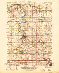
1945 Map of Portland
USGS Topo · Published 1946About this map
The Grand River and Lookingglass River converge at the village of Portland, creating a distinctive hydrologic landscape defined by sharp oxbows and river-driven industry. This mid-1940s survey captures the region as a network of small agricultural centers and rural school districts, many named for local families like the Collins Sch, Keefer Sch, and Dutton Sch. The presence of the Wagar Dam and Weber Dam reflects the ongoing importance of the river for power and infrastructure, while the Pere Marquette railroad corridors connect the primary settlements of Grand Ledge, Sunfield, and Lyons. Outside the main town centers, the landscape is punctuated by numerous rural landmarks, including the Portland Country Club and various community focal points such as Danby Ch and the Eagle Cem. The map provides a detailed look at the township divisions and the intricate system of drains and creeks that supported Michigan’s central farmlands.
Find a feature on this map
104 named features on this map. Tap any name to fly to it.
Don’t see what you’re looking for? This feature index may not catch every label — zoom into the map to look around manually.
Map Details
Editions of this 1945 Portland Map
3 editions found
Other maps of this area

1910 · Lansing
USGS Topo · 1:62,500

1912 · Lansing
USGS Topo · 1:62,500

1916 · Ionia
USGS Topo · 1:62,500

1918 · Ionia
USGS Topo · 1:62,500

1918 · Perrinton
USGS Topo · 1:62,500

1927 · De Witt
USGS Topo · 1:62,500

1943 · Perrinton
USGS Topo · 1:62,500

1943 · Ionia
USGS Topo · 1:62,500

1945 · Portland
USGS Topo · 1:62,500

1949 · Charlotte
USGS Topo · 1:62,500