1961 Map of Portland
USGS Topo · Published 1962About this map
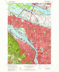
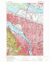
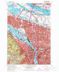
Vanport City (Site) appears as a poignant reminder of the 1948 flood on this early 1960s survey, marking where a major wartime housing development once stood along the Columbia River. The urban landscape is dense with mid-century development, from the industrial activity at the Swan Island Basin and Guild Lake Yard to the established residential grids of Albina, Irvington, and Alameda. The map documents a critical period for transportation infrastructure, showing the Banfield Expressway cutting through Sullivan Gulch and numerous river crossings like the Steel Bridge and Broadway Bridge connecting East Portland to the city center.
Find a feature on this map
120 named features on this map. Tap any name to fly to it.
Don’t see what you’re looking for? This feature index may not catch every label — zoom into the map to look around manually.
Map Details
Editions of this 1961 Portland Map
3 editions found
Other maps of this area

1897 · Portland
USGS Topo · 1:62,500

1905 · Portland
USGS Topo · 1:62,500

1914 · Oregon City
USGS Topo · 1:62,500

1915 · Hillsboro
USGS Topo · 1:62,500

1916 · Tualatin
USGS Topo · 1:62,500

1918 · Hillsboro
USGS Topo · 1:62,500

1939 · Oregon City
USGS Topo · 1:62,500

1939 · Tualatin
USGS Topo · 1:62,500

1940 · Tualatin
USGS Topo · 1:62,500

1940 · Hillsboro
USGS Topo · 1:62,500