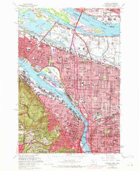
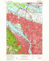
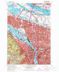
1961 Map of Portland
USGS Topo · Published 1971About this map
The Willamette River and Columbia River converge in this detailed look at a burgeoning Pacific Northwest hub. Industrial activity is concentrated along the waterways, notably at the Port of Portland and the Swan Island Basin shipyard, while the city's residential character expands through established neighborhoods like Irvington, Alameda, and Portland Heights. A complex network of transit infrastructure, including the Union Pacific and Southern Pacific railroads, supports the region's economy alongside major spans like the Steel Bridge and Broadway Bridge.
Find a feature on this map
112 named features on this map. Tap any name to fly to it.
Don’t see what you’re looking for? This feature index may not catch every label — zoom into the map to look around manually.
Map Details
Editions of this 1961 Portland Map
3 editions found
Other maps of this area

1897 · Portland
USGS Topo · 1:62,500

1905 · Portland
USGS Topo · 1:62,500

1914 · Oregon City
USGS Topo · 1:62,500

1915 · Hillsboro
USGS Topo · 1:62,500

1916 · Tualatin
USGS Topo · 1:62,500

1918 · Hillsboro
USGS Topo · 1:62,500

1939 · Oregon City
USGS Topo · 1:62,500

1939 · Tualatin
USGS Topo · 1:62,500

1940 · Tualatin
USGS Topo · 1:62,500

1940 · Hillsboro
USGS Topo · 1:62,500