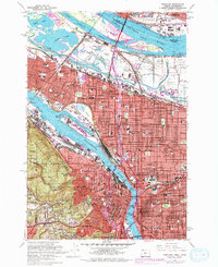
1961 Map of Portland
USGS Topo · Published 1978About this map
Portland and the industrial banks of the Willamette River are showcased in this mid-century period of expansion, featuring updated urban footprints shown in purple. The map details the complex hydraulic environment of the Columbia Slough and the Peninsula Drainage Canal, north of the residential grids of Piedmont and Irvington. Notably, it marks the Vanport City (Site), preserving the location of the former wartime housing development along the Columbia River margin.
Find a feature on this map
88 named features on this map. Tap any name to fly to it.
Don’t see what you’re looking for? This feature index may not catch every label — zoom into the map to look around manually.
Map Details
Editions of this 1961 Portland Map
3 editions found
Other maps of this area

1897 · Portland
USGS Topo · 1:62,500

1905 · Portland
USGS Topo · 1:62,500

1914 · Oregon City
USGS Topo · 1:62,500

1915 · Hillsboro
USGS Topo · 1:62,500

1916 · Tualatin
USGS Topo · 1:62,500

1918 · Hillsboro
USGS Topo · 1:62,500

1939 · Oregon City
USGS Topo · 1:62,500

1939 · Tualatin
USGS Topo · 1:62,500

1940 · Tualatin
USGS Topo · 1:62,500

1940 · Hillsboro
USGS Topo · 1:62,500