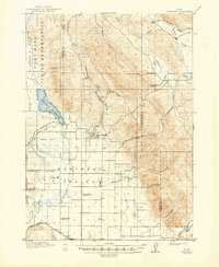
1917 Map of Portneuf
USGS Topo · Published 1948About this map
The Chesterfield settlement stands as a focal point in this high-altitude landscape of southeastern Idaho, surrounded by the agricultural infrastructure of the early twentieth century. The management of water is central to the area's development, evidenced by the Portneuf Reservoir and the extensive Portneuf Valley Irrigation Co Feeder Canal. This network, along with the Land Ditch, supported a valley of rural homesteads and local institutions. Small educational hubs like Gooch School, Rigby School, and Kelly School are scattered across the Portneuf Valley, marking the community's growth.
Find a feature on this map
35 named features on this map. Tap any name to fly to it.
Don’t see what you’re looking for? This feature index may not catch every label — zoom into the map to look around manually.
Map Details
Editions of this 1917 Portneuf Map
3 editions found
Other maps of this area

1914 · Henry
USGS Topo · 1:48,000

1916 · Henry
USGS Topo · 1:62,500

1917 · Portneuf
USGS Topo · 1:62,500

1917 · Cranes Flat
USGS Topo · 1:62,500

1918 · Paradise Valley
USGS Topo · 1:62,500

1948 · Bancroft
USGS Topo · 1:62,500

1948 · Soda Springs
USGS Topo · 1:62,500

1949 · Bancroft
USGS Topo · 1:62,500

1949 · Soda Springs
USGS Topo · 1:62,500

1954 · Pocatello
USGS Topo · 1:250,000