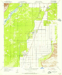
1955 Map of Poston
USGS Topo · Published 1956About this map
Colorado River Indian Reservation lands dominate this mid-century survey, showcasing a landscape transformed by large-scale irrigation and civic planning. The settlements of Poston and Poston 2 are depicted with their characteristic grid layouts, supported by essential community infrastructure like the Poston School. This area served as the site of a major relocation center during the preceding decade, and by the mid-1950s, the map illustrates the enduring physical imprint of that era through its complex network of water management features, including the Main Drain and numerous irrigation laterals such as Lateral A-73.
Find a feature on this map
20 named features on this map. Tap any name to fly to it.
Don’t see what you’re looking for? This feature index may not catch every label — zoom into the map to look around manually.
Map Details
Editions of this 1955 Poston Map
3 editions found
Other maps of this area

1911 · Parker
USGS Topo · 1:125,000

1931 · Moon Mtn
USGS Topo · 1:62,500

1932 · Moon Mtn
USGS Topo · 1:62,500

1942 · Blythe
USGS Topo · 1:250,000

1942 · MOON MTN
USGS Topo · 1:62,500

1943 · Parker
USGS Topo · 1:62,500

1943 · Vidal
USGS Topo · 1:62,500

1945 · Big Maria Mtns
USGS Topo · 1:62,500

1949 · Parker
USGS Topo · 1:62,500

1949 · Vidal
USGS Topo · 1:62,500