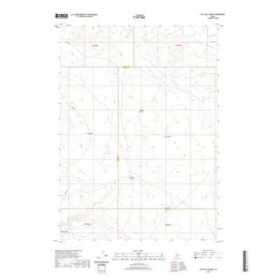
2020 Map of Pot Hole Canyon
USGS Topo · Published 2020About this map
Bruneau Desert dominates this arid landscape, showing the complex drainage systems of the high desert along the border of Elmore and Owyhee counties. The map traces the winding descent of Pot Hole Canyon, where the seasonal waters of Pot Hole Cr have carved into the plateau. This 2020 survey captures the area's sparse infrastructure, defined largely by remote tracks like Pothole Rd and W Noble Rd that cross the townships. To the north and east, the land is dissected by Sailor Creek and its various branches, illustrating the rugged hydrologic patterns of Idaho's Snake River Plain region. The lack of permanent settlements emphasizes the region's character as a wide-open range for grazing and wildlife, where water sources like Sailor Cr are critical landmarks.
Find a feature on this map
15 named features on this map. Tap any name to fly to it.
Don’t see what you’re looking for? This feature index may not catch every label — zoom into the map to look around manually.
Map Details
Editions of this 2020 Pot Hole Canyon Map
This is the sole edition of this map. No revisions or reprints were ever made.
Other maps of this area

1947 · Indian Cove
USGS Topo · 1:24,000

1947 · Hammett
USGS Topo · 1:24,000

1947 · Glenns Ferry
USGS Topo · 1:24,000

1948 · Hammett
USGS Topo · 1:24,000

1948 · Glenns Ferry
USGS Topo · 1:24,000

1948 · Indian Cove
USGS Topo · 1:24,000

1948 · Indian Cove
USGS Topo · 1:62,500

1948 · Glenns Ferry
USGS Topo · 1:62,500

1948 · Pence Butte
USGS Topo · 1:24,000

1948 · Grindstone Butte
USGS Topo · 1:24,000