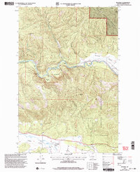
1999 Map of Potomac
USGS Topo · Published 2003About this map
Blackfoot River flows prominently through this Missoula County landscape, serving as a focal point for recreation and land management at the turn of the 21st century. The map highlights several dedicated fishing spots, including River Bend Fishing Access and Thibodeau Fishing Access, alongside the turbulent Thibodeau Rapids. To the south, the settlement of Potomac sits within a valley shaped by Union Creek and Camas Creek, illustrating the area's transition from open valley floor to heavily timbered ridges.
Find a feature on this map
28 named features on this map. Tap any name to fly to it.
Don’t see what you’re looking for? This feature index may not catch every label — zoom into the map to look around manually.
Map Details
Editions of this 1999 Potomac Map
This is the sole edition of this map. No revisions or reprints were ever made.
Other maps of this area

1902 · Ovando
USGS Topo · 1:125,000

1903 · Bonner
USGS Topo · 1:125,000

1905 · Ovando
USGS Topo · 1:125,000

1919 · Drummond
USGS Topo · 1:125,000

1921 · Drummond
USGS Topo · 1:125,000

1921 · Elbow Lake
USGS Topo · 1:125,000

1947 · Butte
USGS Topo · 1:250,000

1955 · Choteau
USGS Topo · 1:250,000

1957 · Choteau
USGS Topo · 1:250,000

1958 · Butte
USGS Topo · 1:250,000