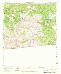
1960 Map of Potrero
USGS Topo · Published 1967About this map
Potrero and the surrounding borderlands of southern San Diego County are captured here during the early 1960s, revealing a landscape defined by significant water management and international boundary markers. The map details the massive catchments of Barrett Lake and Morena Reservoir, controlled by Barrett Dam and Morena Dam, which were essential to the region's water infrastructure. To the south, the California Baja California line is clearly delineated, anchored by the Customhouse near Tecate.
Find a feature on this map
68 named features on this map. Tap any name to fly to it.
Don’t see what you’re looking for? This feature index may not catch every label — zoom into the map to look around manually.
Map Details
Editions of this 1960 Potrero Map
2 editions found
Other maps of this area

1893 · El Cajon
USGS Topo · 1:62,500

1901 · Elcajon
USGS Topo · 1:62,500

1903 · Cuyamaca
USGS Topo · 1:125,000

1903 · Elcajon
USGS Topo · 1:62,500

1904 · Southern California Sheet No. 2
USGS Topo · 1:250,000

1931 · Carrizo
USGS Topo · 1:125,000

1939 · El Cajon
USGS Topo · 1:62,500

1939 · Campo
USGS Topo · 1:62,500

1942 · Potrero
USGS Topo · 1:48,000

1942 · El Cajon
USGS Topo · 1:62,500