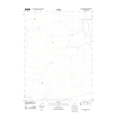
2012 Map of Potter Mountain
USGS Topo · Published 2012About this map
Potter Mountain rises above a high-desert landscape defined by scarce water sources and isolated ranching outposts in Sweetwater County. In this arid environment, the survival of the Pio Moses Ranch is inextricably linked to the management of surface water, evidenced by the Pio Reservoir and the nearby Pio Spring. The drainage of Salt Wells Cr and the deep cuts of Laney Canyon and Dry Canyon reveal a geography shaped by seasonal runoff and persistent aridity. Localized water points such as Laney Spring and Jim Washum Spring provide critical landmarks for those navigating the terrain between Elk Butte and the southern uplands. This area remains largely accessed by unpaved tracks like Moses Ranch Rd and BLM Road 4405, reflecting the sustained ranching and public land management character of the region.
Find a feature on this map
13 named features on this map. Tap any name to fly to it.
Don’t see what you’re looking for? This feature index may not catch every label — zoom into the map to look around manually.
Map Details
Editions of this 2012 Potter Mountain Map
This is the sole edition of this map. No revisions or reprints were ever made.
Other maps of this area

1954 · Rock Springs
USGS Topo · 1:250,000

1958 · Rock Springs
USGS Topo · 1:250,000

1962 · Rock Springs
USGS Topo · 1:250,000
1963 · Titsworth Gap
USGS Topo · 1:24,000

1963 · Four J Rim
USGS Topo · 1:24,000
1963 · Potter Mountain
USGS Topo · 1:24,000
1963 · Red Creek Ranch
USGS Topo · 1:24,000

1963 · Erickson-Kent Ranch
USGS Topo · 1:24,000

1963 · Scrivner Butte
USGS Topo · 1:24,000

1968 · Mud Springs Ranch
USGS Topo · 1:24,000