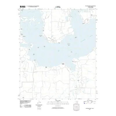
2010 Map of Potters Point
USGS Topo · Published 2010About this map
Big Lake and its intricate network of sloughs and bayous dominate this landscape at the Texas-Louisiana border. The settlement of Uncertain sits on the western edge of the water, near the Fly-N-Fish Lodge Airport, while the peninsula of Potters Point extends into the lake from the north. The map reveals an aquatic-dependent geography defined by features like Whangdoodle Pass, Stumpy Slough, and Mossy Brake, illustrating the complex hydrology of the Cypress Bayou system.
Find a feature on this map
72 named features on this map. Tap any name to fly to it.
Don’t see what you’re looking for? This feature index may not catch every label — zoom into the map to look around manually.
Map Details
Editions of this 2010 Potters Point Map
This is the sole edition of this map. No revisions or reprints were ever made.
Other maps of this area

1932 · Hosston SW
USGS Topo · 1:31,680

1944 · Kildare
USGS Topo · 1:62,500

1944 · Caddo Lake
USGS Topo · 1:62,500

1946 · Caddo Lake
USGS Topo · 1:62,500

1948 · Kildare
USGS Topo · 1:62,500

1948 · Mooringsport
USGS Topo · 1:62,500

1948 · Vivian
USGS Topo · 1:62,500

1955 · Shreveport
USGS Topo · 1:250,000

1955 · Mooringsport
USGS Topo · 1:62,500

1956 · Shreveport
USGS Topo · 1:250,000