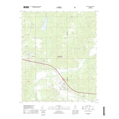
2018 Map of Potts Camp
USGS Topo · Published 2018About this map
Potts Camp serves as the primary hub in this portion of the Holly Springs National Forest, where the landscape is defined by the headwaters of the Tippah River. The town sits at the intersection of local history and northern Mississippi geography, marked by several prominent family and community burial grounds including Potts Camp Cem, Saint Mary Cem, and Butler Cem. To the south, the settlement of Winborn lies along Oaklimeter Creek, while the northern reaches feature the recreational waters of Chewalla Lake. The map reveals a transition from the structured street grid of Potts Camp to the dispersed rural communities of Waites and Lake Center. This detailed survey preserves the placement of many remote cemeteries like Bethany Cem and Harmony Cem, which often represent the only remaining markers of early homesteads in the Marshall and Benton County borderlands.
Find a feature on this map
49 named features on this map. Tap any name to fly to it.
Don’t see what you’re looking for? This feature index may not catch every label — zoom into the map to look around manually.
Map Details
Editions of this 2018 Potts Camp Map
This is the sole edition of this map. No revisions or reprints were ever made.
Other maps of this area

1944 · Potts Camp
USGS Topo · 1:62,500

1945 · Potts Camp
USGS Topo · 1:62,500

1950 · Ashland
USGS Topo · 1:62,500

1953 · Holly Springs
USGS Topo · 1:62,500

1955 · Blue Mountain
USGS Topo · 1:62,500

1956 · Tupelo
USGS Topo · 1:250,000

1958 · Tupelo
USGS Topo · 1:250,000

1964 · Waterford
USGS Topo · 1:24,000

1964 · Holly Springs SE
USGS Topo · 1:24,000
1965 · Holly Springs
USGS Topo · 1:24,000