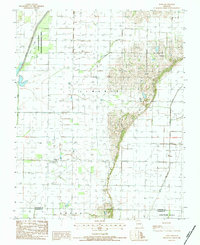
1984 Map of Powe
USGS Topo · Published 1984About this map
Powe and Pyletown anchor this southeastern Missouri landscape, where the flat agricultural terrain of Liberty and Union townships meets the drainage networks of the St. Francis River basin. The western edge is defined by the Otter Slough State Wildlife Management Area, a preserved remnant of the region's original wetland environment before extensive land reclamation. The map illustrates the complex hydrography of the Bootheel, featuring the channelized Main Ditch and the natural meanders of Otter Slough. These water systems dictate the placement of roads and farmsteads, reflecting a landscape heavily modified for productivity in the early 1980s. A distinct topographical transition occurs near the Stoddard and Dunklin County line, where the lowlands give way to the rising elevation of Cotton Hill.
Find a feature on this map
9 named features on this map. Tap any name to fly to it.
Don’t see what you’re looking for? This feature index may not catch every label — zoom into the map to look around manually.
Map Details
Editions of this 1984 Powe Map
This is the sole edition of this map. No revisions or reprints were ever made.
Other maps of this area

1934 · Bloomfield
USGS Topo · 1:62,500

1934 · Puxico
USGS Topo · 1:62,500

1939 · Bloomfield
USGS Topo · 1:62,500

1939 · Puxico
USGS Topo · 1:62,500

1940 · Malden
USGS Topo · 1:62,500

1940 · Valley Ridge
USGS Topo · 1:62,500

1949 · Bloomfield
USGS Topo · 1:62,500

1956 · Valley Ridge
USGS Topo · 1:62,500

1956 · Malden
USGS Topo · 1:62,500

1956 · Dyersburg
USGS Topo · 1:250,000