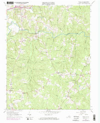
1963 Map of Powellton
USGS Topo · Published 1974About this map
The Meherrin River winds through the heart of Brunswick County, defining a landscape of traditional rural Virginia settlements and family estates. In the northwest, the colonial site of Fort Christanna stands near the riverbanks, marking a notable point of early frontier history. Small communities like Powellton, Greentown, and Brunswick are connected by a network of local routes such as Rawlings Road, while the Meherrin-Powellton Sch serves as a central social hub for the surrounding countryside.
Find a feature on this map
69 named features on this map. Tap any name to fly to it.
Don’t see what you’re looking for? This feature index may not catch every label — zoom into the map to look around manually.
Map Details
Editions of this 1963 Powellton Map

Other maps of this area

1918 · Lawrenceville
USGS Topo · 1:62,500

1919 · Mc Kenney
USGS Topo · 1:48,000

1919 · White Plains
USGS Topo · 1:48,000

1919 · Emporia
USGS Topo · 1:62,500

1920 · Lawrenceville
USGS Topo · 1:48,000

1920 · White Plains
USGS Topo · 1:62,500

1921 · Mc Kenney
USGS Topo · 1:62,500

1921 · Lawrenceville
USGS Topo · 1:62,500

1942 · Lawrenceville
USGS Topo · 1:62,500

1942 · Emporia
USGS Topo · 1:62,500