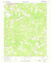
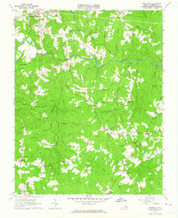
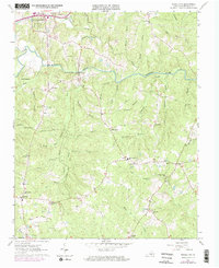
1963 Map of Powellton
USGS Topo · Published 1974About this map
Fort Christanna and the winding course of the Meherrin River anchor this mid-century portrait of southern Virginia. The landscape is defined by its dendritic drainage patterns, with numerous branches such as Rock Branch and Meadow Branch feeding into the river. Small agrarian settlements and crossroads communities like Ezell, Powellton, and James Square are connected by a network of local roads including Rawlings Road, while a massive pipeline cuts a distinct path across the northern terrain.
Find a feature on this map
66 named features on this map. Tap any name to fly to it.
Don’t see what you’re looking for? This feature index may not catch every label — zoom into the map to look around manually.
Map Details
Editions of this 1963 Powellton Map
Other maps of this area

1918 · Lawrenceville
USGS Topo · 1:62,500

1919 · Mc Kenney
USGS Topo · 1:48,000

1919 · White Plains
USGS Topo · 1:48,000

1919 · Emporia
USGS Topo · 1:62,500

1920 · Lawrenceville
USGS Topo · 1:48,000

1920 · White Plains
USGS Topo · 1:62,500

1921 · Mc Kenney
USGS Topo · 1:62,500

1921 · Lawrenceville
USGS Topo · 1:62,500

1942 · Lawrenceville
USGS Topo · 1:62,500

1942 · Emporia
USGS Topo · 1:62,500