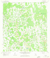
1959 Map of Poyner
USGS Topo · Published 1972About this map
The Green Swamp dominates this late 1950s survey of the Polk and Lake County border, revealing an intricate landscape of wetlands and intermittent water. The Withlacoochee River winds through the northwestern corner, near the defunct corridor of an Old Railroad Grade. Small settlements and rail stops like Eva, Berry, and Poyner serve as focal points for the local community, clustered near the Seaboard Air Line tracks.
Find a feature on this map
18 named features on this map. Tap any name to fly to it.
Don’t see what you’re looking for? This feature index may not catch every label — zoom into the map to look around manually.
Map Details
Editions of this 1959 Poyner Map
4 editions found
Other maps of this area

1944 · Providence
USGS Topo · 1:31,680

1944 · Polk City
USGS Topo · 1:31,680

1955 · Orlando
USGS Topo · 1:250,000

1957 · Orlando
USGS Topo · 1:250,000

1958 · Orlando
USGS Topo · 1:250,000

1959 · Gum Lake
USGS Topo · 1:24,000

1959 · Lake Nellie
USGS Topo · 1:24,000

1959 · Lake Louisa
USGS Topo · 1:24,000

1959 · Lake Louisa SW
USGS Topo · 1:24,000

1959 · Poyner
USGS Topo · 1:24,000