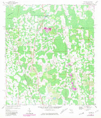
1959 Map of Poyner
USGS Topo · Published 1981About this map
Green Pond Ch and the small settlements of Eva and Poyner define this mid-century landscape along the boundary of Lake and Polk Counties. The area is characterized by an extensive network of wetlands and wooded lowlands surrounding the Withlacoochee River, which flows through the northwest corner. A Gaging Sta on the river and a prominent Ditch in the northeast reflect local water management efforts in this swampy interior. Transportation is a central theme, with the active Seaboard Coast Line railway cutting through the center while an Old Railroad Grade and Rock Ridge Road trace older paths through the terrain. To the north, Rattlesnake Ridge provides one of the few named topographic elevations in a region otherwise dominated by level wetlands. The map also documents the community of Berry and the transition from 1950s planetable surveys to 1980 photorevised updates.
Find a feature on this map
12 named features on this map. Tap any name to fly to it.
Don’t see what you’re looking for? This feature index may not catch every label — zoom into the map to look around manually.
Map Details
Editions of this 1959 Poyner Map
4 editions found
Other maps of this area

1944 · Providence
USGS Topo · 1:31,680

1944 · Polk City
USGS Topo · 1:31,680

1955 · Orlando
USGS Topo · 1:250,000

1957 · Orlando
USGS Topo · 1:250,000

1958 · Orlando
USGS Topo · 1:250,000

1959 · Gum Lake
USGS Topo · 1:24,000

1959 · Lake Nellie
USGS Topo · 1:24,000

1959 · Lake Louisa
USGS Topo · 1:24,000

1959 · Lake Louisa SW
USGS Topo · 1:24,000

1959 · Poyner
USGS Topo · 1:24,000