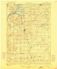
1901 Map of Poynette
USGS Topo · Published 1916About this map
The Wisconsin River cuts through the northwest corner of this turn-of-the-century landscape, framing a region defined by its transition from riverine wetlands to organized agricultural townships. Settled along the Chicago Milwaukee and St. Paul railroad, the village of Poynette stands as a central hub for the surrounding rural communities. The map captures a detailed network of early roads and rail lines connecting smaller hamlets such as Wyocena, Morrisonville, and the three distinct Leeds settlements—Leeds, North Leeds, and Leeds Center.
Find a feature on this map
34 named features on this map. Tap any name to fly to it.
Don’t see what you’re looking for? This feature index may not catch every label — zoom into the map to look around manually.
Map Details
Editions of this 1901 Poynette Map
3 editions found
Other maps of this area

1890 · Madison
USGS Topo · 1:62,500

1890 · Sun Prairie
USGS Topo · 1:62,500

1892 · Madison
USGS Topo · 1:62,500

1895 · Baraboo
USGS Topo · 1:62,500

1896 · Sun Prairie
USGS Topo · 1:62,500

1901 · Poynette
USGS Topo · 1:62,500

1902 · Portage
USGS Topo · 1:62,500

1902 · Briggsville
USGS Topo · 1:62,500

1904 · Madison
USGS Topo · 1:62,500

1905 · Sun Prairie
USGS Topo · 1:62,500