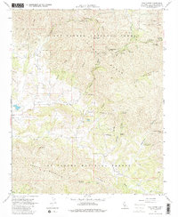
1967 Map of Pozo Summit
USGS Topo · Published 1980About this map
The La Panza Range and Garcia Mountain dominate this section of the Los Padres National Forest, where the headwaters of the Salinas River emerge. The small settlement of Pozo sits in a valley at the center of the sheet, served by the Pozo Sch and a nearby Landing Strip. The map reveals a landscape defined by rugged canyons and seasonal water sources, featuring numerous named springs like Big Spring, Douglas Spring, and American Canyon Spring. Recreation and early land use are evident through multiple established campsites, including Navajo Campground and Balm of Gilead Campground. The presence of several Prospect labels and a Gravel Pit indicates the historical interest in the geological resources of the high country, while a network of jeep trails and the Pozo Summit pass highlight the era's primary transportation routes through the wilderness.
Find a feature on this map
41 named features on this map. Tap any name to fly to it.
Don’t see what you’re looking for? This feature index may not catch every label — zoom into the map to look around manually.
Map Details
Editions of this 1967 Pozo Summit Map
2 editions found
Other maps of this area

1922 · Pozo
USGS Topo · 1:62,500

1922 · Nipomo
USGS Topo · 1:62,500

1932 · La Panza
USGS Topo · 1:48,000

1935 · La Panza
USGS Topo · 1:62,500

1936 · La Panza
USGS Topo · 1:62,500

1937 · Branch Mtn
USGS Topo · 1:48,000

1942 · Branch Mountain
USGS Topo · 1:62,500

1947 · San Luis Obispo
USGS Topo · 1:250,000

1948 · San Luis Obispo
USGS Topo · 1:250,000
1952 · La Panza
USGS Topo · 1:62,500